


STOWE TWP WD 03, Allegheny County, Pennsylvania
About
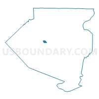
Outline

Summary
| Unique Area Identifier | 656716 |
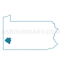
| Name | STOWE TWP WD 03 |
| County | Allegheny County |
| State | Pennsylvania |
| Area (square miles) | 0.81 |
| Land Area (square miles) | 0.67 |
| Water Area (square miles) | 0.14 |
| % of Land Area | 82.15 |
| % of Water Area | 17.85 |
| Latitude of the Internal Point | 40.48203050 |
| Longtitude of the Internal Point | -80.06055130 |
Maps

Graphs
Select a template below for downloading or customizing gragh for STOWE TWP WD 03, Allegheny County, Pennsylvania


Neighbors
Neighoring Voting District (by Name) Neighboring Voting District on the Map
- BELLEVUE WD 01 DIST 01, Allegheny County, PA
- BELLEVUE WD 02 DIST 01, Allegheny County, PA
- BELLEVUE WD 02 DIST 02, Allegheny County, PA
- MC KEES ROCKS WD 01 DIST 01, Allegheny County, PA
- MC KEES ROCKS WD 02 DIST 01, Allegheny County, PA
- MC KEES ROCKS WD 02 DIST 02, Allegheny County, PA
- PITTSBURGH WD 27 DIST 12, Allegheny County, PA
- STOWE TWP WD 01, Allegheny County, PA
- STOWE TWP WD 02 DIST 01, Allegheny County, PA
- STOWE TWP WD 02 DIST 02, Allegheny County, PA
- STOWE TWP WD 04 DIST 01, Allegheny County, PA
Top 10 Neighboring County Subdivision (by Population) Neighboring County Subdivision on the Map
- Pittsburgh city, Allegheny County, PA (305,704)
- Bellevue borough, Allegheny County, PA (8,370)
- Stowe township, Allegheny County, PA (6,362)
- McKees Rocks borough, Allegheny County, PA (6,104)
Top 10 Neighboring Place (by Population) Neighboring Place on the Map
Top 10 Neighboring Unified School District (by Population) Neighboring Unified School District on the Map
- Pittsburgh School District, PA (309,086)
- Northgate School District, PA (13,075)
- Sto-Rox School District, PA (12,466)
Top 10 Neighboring State Legislative District Lower Chamber (by Population) Neighboring State Legislative District Lower Chamber on the Map
- State House District 45, PA (62,568)
- State House District 16, PA (58,551)
- State House District 19, PA (55,312)
- State House District 27, PA (55,311)
Top 10 Neighboring State Legislative District Upper Chamber (by Population) Neighboring State Legislative District Upper Chamber on the Map
Top 10 Neighboring 111th Congressional District (by Population) Neighboring 111th Congressional District on the Map
Top 10 Neighboring Census Tract (by Population) Neighboring Census Tract on the Map
- Census Tract 4626, Allegheny County, PA (3,735)
- Census Tract 4644, Allegheny County, PA (3,442)
- Census Tract 4315, Allegheny County, PA (3,088)
- Census Tract 2701, Allegheny County, PA (2,649)
- Census Tract 4621, Allegheny County, PA (2,627)
- Census Tract 9809, Allegheny County, PA (1,797)